
Daily Rain Chances Return This Week
- Sumner County Severe
- Aug 31, 2025
- 3 min read

If you’ve been enjoying the sunshine lately, get ready for a bit of a change. Starting tomorrow, we’ll see daily chances for rain that will hang around through Thursday. Now—before anyone panics—this doesn’t mean we’re in for four straight days of downpours. Instead, we’re talking about scattered showers that will pop up here and there, mainly in the afternoons.
Why the afternoons? That’s when the sun has had time to heat up the ground, giving the atmosphere a little extra “fuel” to spark those showers and storms. Think of it like boiling a pot of water—once it bubbles long enough, steam rises. The atmosphere works in a similar way, and that’s why afternoons are usually the prime time for rain this time of year.
That said, I wouldn’t rule out the occasional morning shower. So, if you’re headed out early to work, school, or events, it’s smart to keep an umbrella in the car just in case.
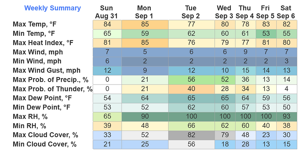
When Are Rain Chances Highest?

Tuesday & Wednesday: These will be the “rainiest” days of the week, with about a 50% chance of showers or a storm in the afternoon. That doesn’t mean it rains all day or everywhere, but it’s a coin flip whether your backyard gets wet.
Monday & Thursday: Lower chances, more in the 20–30% range. Showers will be more scattered, so many areas may stay dry.
Here’s the good news: no severe weather is expected. That means no damaging winds, no hail, no tornado threats. We could hear some rumbles of thunder here and there, but overall this is a “garden variety” rain pattern.
Rainfall totals by the end of the week will average about half an inch to an inch. Unfortunately, with our worsening drought conditions, that won’t do much to improve things. We’d need several rounds of steady, soaking rain to really make a dent.
Temperature Outlook
Today & Monday (Labor Day): Highs will be near normal, right around what you’d expect for early September.
Tuesday–Thursday: Thanks to the added clouds and occasional showers, highs will be held down a bit—upper 70s to lower/mid 80s. That may not sound like much, but you’ll feel the difference.
Friday: Here’s the part I think many of you will love. A cold front (basically a push of cooler, drier air) sweeps through. This one doesn’t bring rain—but it does bring some refreshing air behind it. Morning lows will dip into the low 50s, and dewpoints (what measures the “stickiness” of the air) will also settle in the 50s. That means we’ll finally shake off the muggy air and get a crisp, fall-like feel heading into next weekend.
Bottom Line
Keep the umbrella handy Monday–Thursday.
Best rain chances are Tuesday and Wednesday (around 50%).
No severe weather concerns—just some rumbles of thunder.
Rainfall won’t be enough to help the drought much.
Cooler, drier air arrives Friday.
We Want Your Feedback!
Here at SumnerSevereWx, everything I do is about keeping you informed and safe while making weather easy to understand. And I want to hear from YOU.
👉 Take a quick survey and let me know how I can make SumnerSevereWx even better. What do you love? What should change? What else would you like to see?
Your feedback helps shape the future of SumnerSevereWx, and together we can make sure our community stays weather-ready.


Comments