
Storm Update: Quiet Now…
- Sumner County Severe
- Apr 25
- 4 min read

Hey SumnerSevereWx Fam,
Let’s take a minute and walk through this together, because this is one of those setups where patience matters just as much as preparation.
Today: Mostly Quiet, But Not Bone Dry
We’re in a pretty decent spot today.
Most of us are going to stay dry, and if you’ve got outdoor plans, I’d move forward with them. No reason to cancel anything. That said, I don’t want you completely caught off guard either.
There is still a small chance for a stray shower or a non-severe thunderstorm this afternoon, mainly south of that boundary sitting across Middle Tennessee. Coverage is low. Impact is low. But it’s there.
The game plan is simple. Enjoy your day. Keep an eye on the radar. If thunder shows up, head inside
Nothing more than that.
Sunday: About As Good as It Gets
Sunday is your reward day.
Dry, Warm, Highs in the low to mid 80s
Honestly, just a really solid spring day across the area. If you’ve been waiting to get outside, that’s your window.

Now Let’s Talk About Monday:
This is where things start to get more serious.
Not panic-worthy. Not hype-worthy. But definitely something to respect.
What We Know Right Now:
The Storm Prediction Center has us in a 15 percent risk. That means there is a real chance of severe weather within 25 miles of any point in that zone.
Timing is still being worked out, but everything continues to point toward Monday evening into the overnight hours.
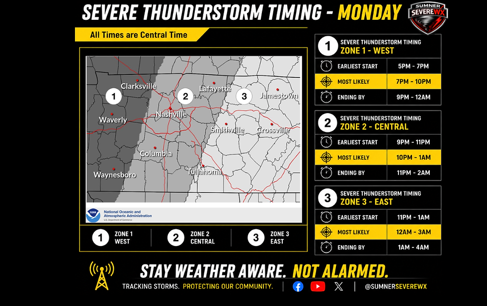
That matters, because nighttime storms always get more attention from me. People are asleep. Awareness drops. That’s when preparation matters most.
What It Looks Like?
The most likely setup is a line of storms moving in from the west.
Not isolated supercells everywhere. Not a widespread outbreak here locally
More of a line that has some punch to it as it moves through.
Threats:
All hazards are technically on the table, but let’s be real about what stands out most right now.
Damaging straight-line winds look like the primary concern. Large hail is possible. A few embedded tornadoes cannot be ruled out
That last part is important. Not expected to be widespread, but not something we ignore either.
Why This Isn’t a Slam Dunk Severe Event (Right Now):
This is where experience comes in.
As storms move toward us, they will likely run into a less favorable environment compared to areas northwest of us. That’s where the higher-end severe risk is setting up.
We’re kind of on the edge of that better energy. Instability looks like it may decrease as we go into the overnight hours, which can limit how strong storms remain as they move in.
That’s a big reason I’m not sounding alarms right now.
But hear me clearly…
That does not mean zero risk.
If things trend faster, or the atmosphere holds onto more energy than expected, the ceiling goes up quickly.
Tuesday: Don’t Ignore It:
Tuesday is what we call a conditional setup.
Everything depends on what happens Monday night.
If the atmosphere can recover, we could see another round of storms Tuesday evening into the night, especially across southern Middle Tennessee.
If it can’t recover, Tuesday becomes much quieter.
We won’t know that answer until after Monday plays out.
The Good News: We Need This Rain

I know severe weather gets all the attention, but there’s a positive here.
We’re finally looking at 1 to 3 inches of rain over the next 7 days, with some areas possibly seeing a bit more. We need it.
Flooding concerns remain low right now because of how dry the ground has been.
So yes, storms come with risk. But they’re also bringing something beneficial with them
Let’s Talk Preparation (This Matters More Than Hype):

I’m going to be posting more detailed prep info over the next couple days, but let’s start simple.
If Monday trends the way it looks right now, this could be a nighttime event.
That means you need to ask yourself a few things now, not Monday night:
Do I have a way to get warnings while I’m asleep?
Is my phone set up properly?
Do I have more than one way to get alerts?
Do I know where I’m going if a warning is issued?
This isn’t about fear. This is about being ready before you need to be
Sources You Can Trust:
There’s a lot of noise out there when severe weather shows up. Stick with sources that are consistent and grounded.
National Weather Service Nashville , Storm Prediction Center, Local Tv Meteorologists, Degreed Meteorologists and the Tspotter Network.
And of course, I’ll be here walking through it with you every step of the way
No hype. No overreaction. Just real, steady updates.
So, Main things to take away!
Today is mostly quiet. Maybe a stray shower.
Sunday is beautiful.
Monday evening into Monday night is our window to watch
There is a real severe threat, but it is not a guarantee. The highest risk stays northwest of us for now.
I'll continue to refine this as better data comes in.
I’ll start tightening up timing and impacts tomorrow as those higher-resolution models really come into play.
Until then
Stay weather aware. Not alarmed
We’ve got this.


Comments