
From Quiet Skies to Storm Chances: What I’m Watching!
- Sumner County Severe
- Apr 23
- 3 min read

We’ve squeezed just about everything we can out of this quiet stretch of weather.
Warm afternoons, comfortable humidity, and sunshine have been the story and honestly, it’s been a great run.
But the atmosphere is starting to shift behind the scenes. Moisture is increasing, the upper pattern is flattening, and disturbances are beginning to move in from the west.
That transition sets the stage for our next round of showers and storms from Friday through Monday, with lingering effects into Tuesday.
Let’s walk through it step-by-step.

FRIDAY: A WEAKENING SYSTEM MOVES IN
By Friday, a weakening cold front approaches from the west. This system starts off stronger across the Plains, but as it moves into Tennessee, it begins to lose organization.
And that’s key.
The Setup:
Instability (CAPE): ~400–800 J/kg during the day
Wind Shear: ~20–25 knots
Lapse Rates: Poor
That’s not a favorable environment for widespread severe weather.
What That Means:
Storms will be:
Scattered
Disorganized
Hit-or-miss
Could a storm briefly pulse up? Sure.
Main Concerns:
Gusty winds
Small hail
But overall: Severe threat is very LOW
FRIDAY NIGHT - SATURDAY MORNING: BEST RAIN CHANCE
As we head into Friday night, a shortwave moves overhead. That’s basically a pocket of energy that helps lift the atmosphere.
More lift = more rain coverage.
What to Expect:
Showers with embedded thunderstorms
More widespread than during the day
Brief heavier downpours possible
Rainfall:
Generally, 0.25" to 0.50"
Locally higher spots possible
Good rain—but not a washout.
I know we have Nashville Rock n Roll Marathon in the Morning, then Square Fest in Gallatin. I would take a rain jacket/ umbrella just to be safe.
SATURDAY: LESS ORGANIZED, LOWER IMPACT
By Saturday, the main energy shifts east of us.
You might see:
Lingering showers in the morning
A few isolated storms in the afternoon
But the atmosphere just doesn’t have the support to organize storms well.
Translation:
Coverage: Lower
Intensity: Low
Timing: Still messy (don’t try to pin it down too exact)
SUNDAY: A BREAK
A shortwave ridge builds in.
What that means:
Drier conditions
Quieter weather
Highs in the upper 70s to low 80s
Enjoy it, we’ll need it.
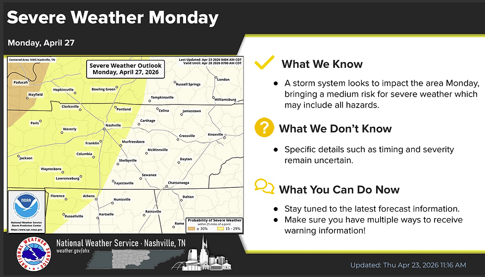
⚠️ MONDAY: THE SYSTEM TO WATCH
This is where things get more interesting.
A stronger, more organized system develops as a negatively tilted trough lifts out of the Four Corners region. That helps deepen a surface low and push a cold front toward Middle Tennessee.
Now we start seeing better ingredients come together.
The Setup (Monday)
CAPE: (Storm fuel)
Up to ~1500 J/kg northwest
~500 J/kg around Nashville and us (The lower the better)
Bulk Shear:
40–60 knots
0–3 km Helicity:
250–350
That’s a much more supportive environment for organized storms.
What This Means
Even though instability may be decreasing slightly as storms move in:
There is still plenty of energy + strong wind shear
That combination supports:
Organized storm structures
Strong to severe storms
Possible Hazards (Monday)
At this point:
All hazards are on the table
Damaging winds
Large hail
Tornado potential
Now—before anyone runs with that…
Important:
This is still a few days out.
Timing, storm mode, and placement of the strongest ingredients WILL change.
But:
This is the day to keep a closer eye on.
Let’s Talk About The Model Data
Looking at the latest GFS guidance:
Instability is moderate at best
Wind profiles show some curvature, but not extreme early on
The better overlap of ingredients improves into Monday
Translation:
Friday/Saturday = messy, low-end
Monday = more organized potential
Summary:
• Today = warm, quiet, enjoy it
• Friday = scattered storms, low severe risk
• Friday night → Saturday = best rain chances
• Sunday = break
• Monday = stronger system, something to watch
• Tuesday = lingering showers, then improving
Severe weather season is here, that’s just reality in Tennessee.
But right now: We’re not looking at a high-end outbreak for us. We ARE looking at an active pattern
And yeah… This might not be the last system we deal with either during this severe weather season.
But let’s not get ahead of ourselves.
We’ll take this one step at a time, Friday through Tuesday first.
Remember to follow Reliable, Trusted, and Degreed Meteorologists. There's a lot of craziness on all social media platforms.... It will drive up your storm anxiety and we DON'T want that!
I'll be here every step of the way!
Stay Weather Aware. Not Alarmed.


Comments